NWS Flood Watch Includes Mason County. Again.

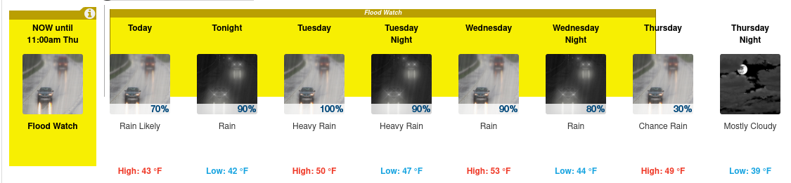
Flood Watch National Weather Service Seattle WA 437 AM PST Mon Jan 10 2022 

Atmospheric river moving into Western Washington tonight and stalling over the area until Wednesday. 

Snow levels rising up to 5000 feet tonight and to 6500 to 8000 feet by Wednesday. 

Heavy rain forecast for the mountains with the heaviest rains over the Olympics. 

Rainfall totals for tonight through Wednesday in the Olympics in the 5 to 10 inch range, North Cascades 3 to 5 inches and 2 to 4 inches in the Central and Southern Cascades. The atmospheric river will lift north of the area late Wednesday. 

437 AM PST Mon Jan 10 2022 ...FLOOD WATCH IN EFFECT THROUGH THURSDAY MORNING... 
* WHAT...Flooding caused by excessive rainfall is possible. 
* WHERE...Portions of northwest Washington and west central Washington, including the following counties, in northwest Washington, Clallam, Grays Harbor, Jefferson, Mason, Skagit and Whatcom. In west central Washington, King and Snohomish. 
* WHEN...Through Thursday morning. 
* IMPACTS...Excessive runoff may result in flooding of rivers, creeks, streams, and other low-lying and flood-prone locations. 
* ADDITIONAL DETAILS... - Heavy rain over the mountains tonight through Wednesday. Rivers flowing out of the Olympics could begin flooding Tuesday with rivers flowing off the Cascades possibly flooding beginning Wednesday.
 PRECAUTIONARY/PREPAREDNESS ACTIONS... You should monitor later forecasts and be alert for possible Flood Warnings. Those living in areas prone to flooding should be prepared to take action should flooding develop. 

Y'all Be Safe Out There! 
Posted in Meetings | Comments Off on NWS Flood Watch Includes Mason County. Again.

It’s Gonna Get COLD! Special Wx Statement

Special Weather Statement National Weather Service Seattle WA 347 PM PST Sun Dec 26 2021 WAZ504-507-509-511>513-515>517-555-556-558-559-567>569-271200-Southwest Interior-Everett and Vicinity-Tacoma Area-Hood Canal Area-Lower Chehalis Valley Area-Olympics-Western Strait of Juan De Fuca-North Coast-Central Coast- East Puget Sound Lowlands-Bellevue and Vicinity-Seattle and Vicinity-Bremerton and Vicinity-Cascades of Whatcom and Skagit Counties-Cascades of Snohomish and King Counties-Cascades of Pierce and Lewis Counties- 347 PM PST Sun Dec 26 2021 ...DANGEROUSLY COLD TEMPERATURES EXPECTED THIS WEEK... Arctic air continues to move into the area and is expected to bring extremely cold temperatures to the region. High temperatures are expected to be in the low to mid 20s with lows in the teens for much of the lowlands. Areas directly near the waters will experience breezier winds, so wind chill values could drop down to the single digits. With these very cold temperatures, frost bite and hypothermia will occur much faster. If outdoors, remember to dress in layers and cover exposed skin. Take precautions to protect pets and livestock from the extreme cold as well. Uncovered pipes will also be susceptible to freezing and bursting. $$ www.weather.gov/seattle 
Posted in Meetings | Comments Off on It’s Gonna Get COLD! Special Wx Statement

Area Flood Watch Thurs thru Sat For Mason County

RAW Weather Service Message:

* WHAT…Flooding caused by excessive rainfall is possible.

* WHERE…A portion of northwest Washington, including the following area, Mason.

* WHEN…From Thursday evening through late Saturday night.

* IMPACTS…Excessive runoff may result in flooding of rivers, creeks, streams, and other low-lying and flood-prone locations.

* ADDITIONAL DETAILS… – Heavy rain will begin on Thursday with flooding possible Thursday night. The Skokomish River will recede on Friday then rise again on Saturday. – http://www.weather.gov/safety/flood

Y’all have a great Thanksgiving and Be Safe!

Posted in Meetings | Comments Off on Area Flood Watch Thurs thru Sat For Mason County

Some Mason County Flooding Possible

Hydrologic Outlook

Hydrologic Outlook WAC045-021800- Hydrologic Outlook National Weather Service Seattle WA 1221 PM PDT Mon Nov 1 2021 ...THREAT OF RIVER FLOODING WEDNESDAY NIGHT THROUGH FRIDAY FOR MASON COUNTY... A vigorous frontal system will bring heavy rain and high snow levels to the south slopes of the Olympic mountains Wednesday night and Thursday. This combination could be enough to push the Skokomish River in Mason County above flood stage later Thursday. Please monitor the latest river forecasts from the National Weather Service for additional information. $$ 16 
Posted in Meetings | Comments Off on Some Mason County Flooding Possible

New Technician Class starts September 28th

Dave Brooks will be teaching a Technician Class beginning Tuesday, September 28th and continue through the end of November.

The class times are 7 to 9 pm at the Department of Emergency Management Office, 100 W Public Works Drive, Shelton, WA. 98584.

The book that is required for the class is the Ham Radio License Manual, 4th edition, published by ARRL (approximately$30.00). Each student will need to purchase their own book.

There is also a $10.00 fee for additional training material needed for the class. 

Contact Dave Brooks (dbbrooks@hotmail.com or 253.363.1692) for more information.

Posted in Training | Comments Off on New Technician Class starts September 28th